.svg)
.svg)
.svg)
.svg)
.svg)
%201%20(2).png)
.png)
.svg)
.svg)
.svg)
.svg)
.svg)
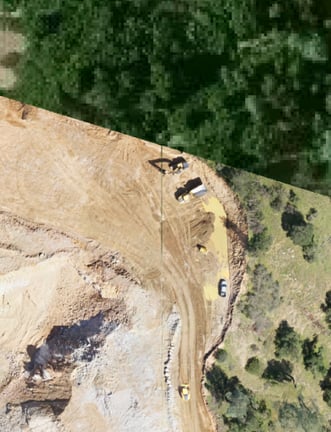
Lehigh Hanson, one of the leading producers of cement and aggregates in North America, recently integrated the use of their drone imagery capabilities to take their environmental compliance processes to new heights. Now, their teams can remotely capture site conditions and collect field data for their compliance documents and maps from the office – all while limiting travel to remote quarry locations. They had been using their drone for operational data, such as stockpile volumes, and were able to leverage the same resource for their environmental teams too.
To stay compliant with permit requirements and growing environmental compliance demands,building materials companies, like most in industry, are required to keep an up-to-date and accurate record of their facility maps and operations data. Maintaining this can be both tedious and time-consuming, often requiring staff to travel to multiple facility locations and spend hours capturing current equipment locations, industrial activity boundaries, and site conditions.
To mitigate this challenge and make their environmental compliance monitoring and documentation processes more efficient, Lehigh Hanson saw an opportunity to integrate drone imagery with their environmental compliance software platform, provided by Mapistry. This integration enables the team to pull drone imagery directly into facility maps and documents in real-time. The timeliness and accuracy of these images greatly improves the team’s ability to depict industrial activity boundaries (e.g. quarry operation extent), capture elevation data and other vital information.
“Drones can capture data from hundreds of acres accurately, reliably and quickly. By integrating drone imagery into the Mapistry platform, we’ve been able to significantly improve the ease and convenience of our recordkeeping and reporting obligations. Drone imagery helps ensure we are correct the first time,” adds Ben Calo, Land and Environmental Specialist from Lehigh Hanson.
The Lehigh Hanson team is able to use Mapistry’s library of intuitive mapping tools to annotate best management practices (BMPs), industrial activity areas, potential pollutant and equipment storage areas. Drone images are overlaid on the existing base map imagery to provide a current background image for stormwater, SPCC, and facility maps. In addition, elevation data, such as topography, and stockpile outlines can also be overlaid into the existing maps.
By leveraging an existing asset used for operational data capture, their drone, and their Mapistry software, the Lehigh Hanson team was able to increase environmental site map accuracy and drive down the time required to update their environmental documents. The expansion of technology within their programs has given Lehigh Hanson business advantages both in operations and in their support of business efficiency and legal obligations via the environmental team.
Want to learn more?
- Learn how to transform environmental data into action